in the Salmon Trout River drainage
Streams have to start somewhere, but their beginning can be ambiguous. The smallest headwater streams — ‘first-order’ streams that have no smaller tributaries — are usually ephemeral, flowing only at snowmelt or after heavy rains. One relatively definite beginning point is the highest point where these headwater streams establish an identifiable channel. These ‘channel heads’ mark the point where more dispersed ‘overland’ flow converges in more concentrated runoff along a consistent pathway with resulting movement of materials and erosion.
Such small headwater streams are rarely shown accurately or consistently (or at all) on maps. However, their number and distribution are important in understanding and modeling landscape hydrology, and in understanding processes of erosion and material export. Hydrologists have developed an alternative to tedious on-the-ground mapping to better understand channel-head distribution; using digital elevation models and geographic information system (GIS) tools, it should be possible to calculate likely locations of channel heads as a function of the interaction between drainage area and slope. However, effective use of this approach calls for sufficient field data to fit the models for landscapes of varying properties.
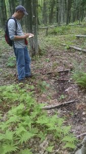
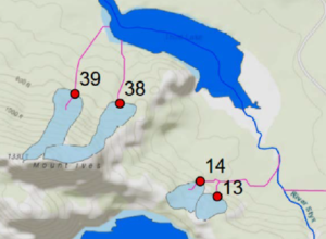
Dr. Christopher Anderson of the School of Forestry at Auburn University works at the interface between stream ecology, hydrology, and stream geomorphology. Spending two field seasons (2016-17) in the Huron Mountain region, Anderson mapped first-order channel heads to test the effectiveness of the ‘slope-area’ method for locating channel-heads. A further objective was to compare the old-growth watersheds of the Huron Mt. Club to previously logged watersheds in the area to ask whether land-use history affected the formation of headwater streams channels. Does logging increase runoff, thereby accelerating the channel forming process and leading to increased density of drainage channels? This question can only be answered by comparisons between similar logged and unlogged landscapes.
(from Anderson, final report to HMWF)
Anderson mapped over 60 channel-heads, and found that the ‘slope-area’ modeling approach worked well; the relationship between catchment area and slope for these stream heads showed the predicted close relationship, suggesting that it should be possible to locate channel heads approximately with GIS models using detailed topographic maps. However, surprisingly, the slope-area relationship for old-growth and previously logged areas did not differ. This might be partly due to another result from his studies; the old-growth areas tended to have thinner soils, leading to more surface flow and channel-head formation.
Initial analyses from Anderson’s study were recently published in the journal Forest Science